Enhancing Safety & Budget Efficiency with the Right Technology
Is It Worth The Cost To Map Your Underground Utilities?
What is Utility Mapping?
Utility mapping involves accurately locating and digitally mapping underground utilities to provide a comprehensive record of subsurface infrastructure. This data ensures safe excavation, reduces utility strikes, and enables targeted maintenance and repairs.
However, many applications claiming to map utilities automatically or store utility as-builts lack accuracy. Outdated or incomplete records result in project managers and facility teams making educated guesses, increasing the risk of striking underground utilities. The Common Ground Alliance’s DIRT Report highlights a growing trend in utility strikes, with 94% attributed to inaccurate or missing location data. These errors create significant financial and operational challenges for general contractors, subcontractors, and facility managers.
Accurate Utility Maps Improve Planning, Construction, and Maintenance
A robust utility mapping approach integrates precise, field-verified location services with advanced digital mapping technology. SiteMap® (patent pending), powered by GPRS, offers a solution that combines 99.8% accurate utility location data with interactive, layered digital utility maps.
Learn more about incorporating a complimentary SiteMap® subscription here.
Four Steps to Avoid Utility Strikes
Before any excavation, directional drilling, or trenching project, follow these four essential steps to mitigate risk.
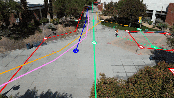
1. Call 811 / One Call First
Federal and state laws mandate that anyone excavating must first contact 811 to request a public utility locate. Each state provides a free 811 service, marking approximate public utility locations with flags or paint. However, 811 locates do not include private utilities, depth measurements, or comprehensive mapping. Find your state’s 811 service here.
GRACE, INSERT THE ONE CALL LOGOS/LINKS HERE
2. Hire a Private Utility Locator
Private utilities constitute over 60% of underground lines in the U.S., yet 811 does not mark them. To ensure full site coverage, hire a professional utility locator to detect and map both public and private utilities. Select a provider that offers:
- On-site utility detection using multi-technology subsurface investigation.
- Accurate, GPS-enabled mapping with deliverables in PDF and KMZ formats.
- Documentation of as-built conditions for future reference.
A utility strike costs an average of $56,000 per incident and results in 6–8 weeks of downtime. The 2021 Finch Report found that 66% of surveyed facility managers had experienced a utility strike in the past five years. Many now allocate budgets for expected utility replacements, driving up costs. In contrast, private utility locating offers a cost-effective preventive measure that can save tens of thousands annually.
3. Update Your Ground Disturbance Policy
General contractors, facility managers, and project owners should update their Ground Disturbance Policy to mandate public and private utility locating before excavation. The most reliable utility locators are SIM-certified, completing:
- 80+ hours of classroom training
- 320+ hours of mentored fieldwork
- A multi-technology approach ensuring 99.8% accuracy
GPRS Project Managers nationwide are SIM-certified and maintain a 99.8% accuracy rate on over 500,000 projects. We also offer a complimentary Ground Disturbance Policy Review to help teams establish best practices. Learn more here.
4. Use a Secure, Shareable Utility Mapping Platform
Not all underground utility maps provide accurate data. Automated utility mapping solutions that rely solely on public records, GIS databases, or AI-generated data often lack accuracy. Many GIS systems only store the data uploaded to them, meaning outdated or fragmented records can lead to costly strikes.
GPRS provides complimentary SiteMap® Personal access to every utility locating customer, along with PDF and KMZ files of each locate. SiteMap® offers:
- Layered, interactive maps for easy visualization.
- Cloud-based access from any device, 24/7.
- 99.8% accurate subsurface utility data for informed decision-making.
Additionally, 3D photogrammetry and laser scanning enable the creation of highly detailed 3D utility maps for advanced planning and design.
Accurate Utility Mapping = Project Safety and Cost Control Hiring a firm that combines precise utility locating with secure data management ensures efficiency, cost savings, and safety.
At GPRS, we say: Data Control = Damage Control™.
Learn more about how GPRS Intelligently Visualizes The Built World® here.