Not all utilities are registered with 811, so additional private utility locating services were required to ensure drilling clearances before excavation.

GPRS Ensures Safe Utility Locating for California Trenching Project
Project Overview
GPRS Project Manager Darrell Fernandez was deployed to San Pablo, California, where a contractor was installing deep well anodes along a gas distribution line in a residential neighborhood. Fernandez validated 811 registered utility markings and identified an unmarked stormwater system that was obstructing the planned path of an 80-foot trench, ensuring the secure installation of deep well anodes along an existing gas distribution line.
Deep Well Anodes: Purpose and Function
Deep well anodes are vertically installed electrodes designed to mitigate corrosion in buried infrastructure such as pipelines and storage tanks. These anodes are positioned within a conductive backfill inside a drilled well, ensuring optimal electrical conductivity to protect critical underground assets. By connecting to a power source, anodes generate a protective current that prevents corrosion of the protected structures, serving as sacrificial components that deteriorate in place of essential buried infrastructure.
Challenges in the Excavation Process
The contractor adhered to regulations by notifying the state’s 811 One Call center, prompting registered utility owners to mark their underground facilities within the excavation zone. The national 811 system serves as a notification network, linking excavators, contractors, and participating utility companies to mitigate excavation risks.
Despite compliance with 811 regulations, the contractor was aware of an unmarked storm drain system within the worksite. Without an accurate map or confirmation of its exact location, the excavation posed significant safety and operational risks. Because not all utilities are registered with 811, additional private utility locating services were required to ensure complete site mapping before excavation commenced.
GPRS Solution: Advanced Utility Locating Technologies
GPRS typically employs video pipe inspection (VPI) to scope, survey, and map storm water systems. This process utilizes remote-controlled CCTV crawlers and push-fed sewer scopes equipped with sondes, which transmit signals that can be tracked to find underground pipelines and identify structural defects like cross bores, inflow/infiltration, and blockages.
However, due to clogged storm drain manholes at this site, standard VPI methods were not viable. Instead, Fernandez leveraged ground penetrating radar (GPR) to conduct subsurface scanning.
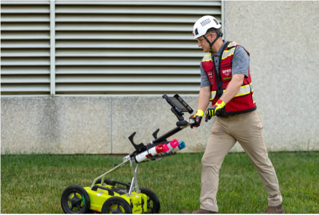
GPRS PM Darrell Fernandez used a GPR utility locating cart like this to find and map a California storm sewer system prior to deep well anode installation in a residential development.
GPR technology emits radio waves into the ground and detects reflected signals from subsurface anomalies, such as buried utilities, structural supports, and underground storage tanks (USTs). GPRS Project Managers are extensively trained to interpret GPR data via Subsurface Investigation Methodology, aka SIM, allowing them to provide precise utility locations and depth estimations.
Using GPR, Fernandez identified an anomaly leading directly to a clogged storm drain manhole.
“I ended up seeing an anomaly with GPR, which led straight to the storm drain manhole which was clogged up,” he stated. “The anomaly I found went straight through the middle of their work area... [So,] we saved the customer from hitting this storm line, which was in the trench path.”
Further scanning revealed multiple unmarked utilities intersecting the planned trenching area. Striking these utilities could have resulted in service disruptions, costly repairs, project delays, and safety hazards for workers and residents. It is important to note approximately 65% of all utility lines on any property or project are private, not public, and the vast majority of private lines are not registered with 811.
Outcome & Documentation
Fernandez successfully identified and marked the storm drain and additional unknown utilities, preventing excavation incidents and ensuring project continuity.
“The client was pleased that the storm drain and a few unknowns were found,” Fernandez noted.
GPRS confirmed 811’s findings for registered utilities and found others, including an unmarked storm sewer system that impeded the intended path of deep well anode installations.
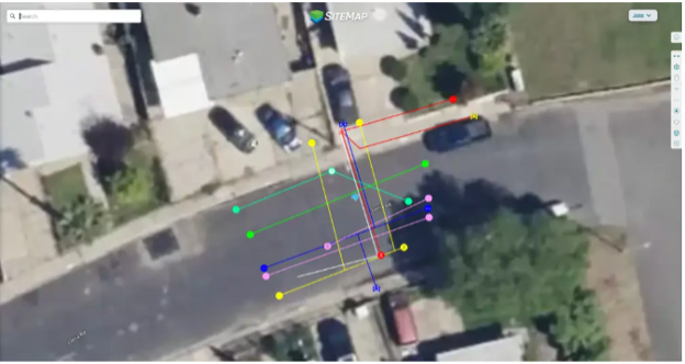
All collected data was uploaded to SiteMap® (patent pending), GPRS’ proprietary project and facility management platform. SiteMap® provides comprehensive existing conditions documentation, offering 24/7 secure access from any computer, tablet, or smartphone. This centralized resource enhances project planning, design, and execution, minimizing errors and facilitating seamless collaboration among stakeholders.
Every GPRS customer receives complimentary SiteMap® Personal access to secure, comprehensive documentation of critical infrastructure data.
Ensuring Project Safety and Efficiency GPRS’ advanced utility locating solutions safeguard projects by mitigating unforeseen subsurface risks, keeping operations on schedule and within budget. From storm drains to high-rise developments, GPRS Intelligently Visualizes The Built World®, ensuring the integrity and safety of every excavation project.
How can we help you visualize your next project?