Underground Private Utility Locating & Mapping
Why Call a Private Utility Locator?
GPRS private utility locating services are part of a suite of visualization tools that allow organizations, facility and project managers, and construction professionals to avoid utility strikes, clashes, reworks, and mistakes to keep your job on time, on budget, and safe.
We help you Intelligently Visualize The Built World® through accurate utility detection, CCTV video pipe inspections, pinpoint leak detection, 3D laser scanning, and photogrammetry, and more to help you execute any construction project while reducing clashes, reworks, delays and utility strikes.
You receive accurate, comprehensive existing conditions documentation & as-builts to help you prevent damages and manage your facility or site by giving you CONTROL.
When you ignore potential clashes and issues below - and above - the ground, you put your project and everyone on it at risk. The consequences can not only be costly, but fatal.
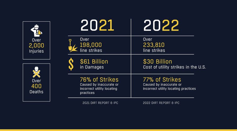
There is a utility strike in the U.S. every 45 seconds. These strikes cause an estimated $61 billion dollars worth of damage per year. 76% of utility strikes that occur during site excavation could be prevented with accurate and complete subsurface as-builts and existing conditions data.
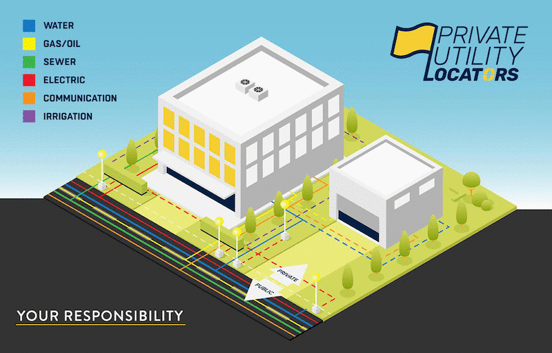
Calling 811 is federally mandated before you begin any excavation project. However, the scope of 811 contracted services is limited to locating public utility lines. Private utilities make up more than 65% of all utility lines, and they often overlap public lines, making clearances even more complicated.
GPRS can locate both private and public utilities on site, provide depths for those lines, and give you a complimentary PDF and .KMZ file, and your own layered, digitized map of every outdoor utility locate job we do via our SiteMap platform.
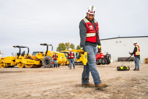
When you hire GPRS, you maintain control: of your site, the accuracy of your data, and your safety because every one of our national “boots on the ground” team of Project Managers is a rapid response professional with over 400 hours of education & training who utilizes a wide variety of technologies and reporting tools to provide you with 99.8% accurate utility locating data. We can say that because we have maintained that accuracy rate on over 500,000 jobs nationwide.
When You Work With GPRS, You Get:
- A team of elite GPRS Project Managers who are specially trained and ready to help map the world to new depths. Project Managers are trained in Subsurface Investigation Methodology (SIM), the highest certification standard in the industry
- Accurate existing conditions documentation and as-builts, private and public utility maps, 2D CAD drawings, and 3D photogrammetry and Building Information Models (BIM), depending on your needs
- 24/7 secure access to your 99.8% accurate GPRS subsurface data via our SiteMap® platform
- Your own SiteMap® Personal account, so you can view & securely share your utility information with your team
- A service with verifiable accuracy, utilizing the finest technology and data collection methods available
- And more!
We find & inspect:
Utility Lines - Water & Wastewater Systems - Fire Suppressions Systems - Telecom & Fiber Optic Lines - Soil Boring Clearances - Leaks - Clashes - Concrete Reinforcements - Underground Storage Tanks - Cross Bores - and More
If you need to see it, above or below-ground, GPRS can visualize it for you
Property owners and those they employ are always responsible for locating private utilities before breaking ground. When looking for a utility locator near you, selecting one who can meet your needs and provide clear communication and accurate locates is vital. GPRS consistently offers elite customer service as well as the most accurate utility locating services and results you can get.
Private subsurface utilities represent over 65% of all buried utility lines. So, 811 services are giving you half the picture. Putting together the rest of your subsurface picture falls to you, which is why it’s so important to utilize both your state’s One Call service and a private utility locator.
Because the scope of 811 is limited, it is crucial to secure your jobsite and the area around it, by hiring a SIM-certified subsurface locator like GPRS.

You can also download our guidebook entitled 6 Steps to a Safe Job Site, which provides instructions for establishing a safe environment before excavation begins.

Call 811 (One Call System) and ensure all public utilities are properly marked

Ask key personnel at the facility for knowledge on underground information and documentation
Walk the job site and excavation area to search for visual indications of underground utilities
Review existing as-built utility drawings for the site and specific excavation area

Hire a qualified private utility locator
- Ensure that the private utility locator uses multiple locating technologies such as GPR and Electromagnetic Locators
- Ensure that the private utility locator provides a map or drawing of their findings
- Walk the job site with the private utility locator to review the results of the underground utility locate

Expose all located lines via pot-holing (vacuum excavation)
Hold a pre-excavation meeting with all involved parties to review the map provided by the private utility locator, and cross-reference with any existing maps, 811 results, and the results of the vacuum excavation
Utility Strikes are Costly and Dangerous
Ignorance isn’t always bliss.
There is a utility strike every 45 seconds in the US, and 67% of facility managers report that they’ve experienced a utility strike or locating issue in the last five years.
Without the ability to locate and accurately see private utilities, you’re risking more than just your time, you may even risk your life, and the lives of others.
The responsibility of damages or severed line strikes during your excavation is yours. Since 2000, there have been thousands of injuries and hundreds of deaths that resulted from insufficient ground disturbance policies at construction and other job sites.
The most effective tool you have to avoid those damages, accidents, and fatalities is hiring a private utility locator like GPRS.
How Do Utility Locating Services Work?
The goal of GPRS' utility locating services is to identify the type and location of buried utility lines to prevent unnecessary damage or injury to field personnel during excavation. At GPRS we believe that data control = damage control and we are committed to the pursuit of 100% subsurface damage prevention – on every job, in every market, nationwide. GPRS uses state-of-the-art tools to provide the industry’s most accurate utility detection services. We utilize ground penetrating radar, electromagnetic induction and locating, thermal scanning, acoustic leak detection and leak correlators, 3D laser scanners, and CCTV sewer scope camera systems to help provide a clear and precise picture of the location and condition of utility lines beneath your job site.
GPRS is the only company in the U.S. that can capture your entire site or facility, above and below-ground, to provide you with accurate as-builts, private and public utility maps, 2D CAD drawings, and 3D photogrammetry and Building Information Models (BIM) that can integrate surface and subsurface existing conditions and construction progress capture to provide cloud-based, digital mapping & modeling solutions for the construction, architecture, engineering, facility management, and related industries via SiteMap®.
The Accuracy of GPRS Private Utility Locating
To ensure the accurate and comprehensive locating of buried private utility lines, customers need to contact a private utility locating contractor such as GPRS. While there are many service providers available, none of them have the abilities or the accuracy rating that GPRS does. Our industry-leading SIM specifications and technology provide the most comprehensive visualization of your existing subsurface utilities. So you can avoid mistakes, miscommunications, accidents, clashes, damages, and strikes.
GPRS attained a 99.8%+ subsurface damage prevention rate through a revolutionary industry standard. Subsurface Investigation Methodology, or SIM, is the industry-leading, metrics-based guideline for the underground locating and concrete scanning industries. SIM includes 3 core elements: equipment, training, and methodology. All GPRS Project Managers are SIM-certified, completing weeks of classroom training and months of field mentoring. Our field personnel aren’t just technicians; this is their career, craft, and trade.
We provide complimentary KMZ and PDF maps with every utility locate we perform. Our Mapping & Modeling Team can create anything from a simple GPS-enabled locating map of your utility locate, to highly-detailed 2D CAD drawings and 3D BIM models, depending on your needs. All data, maps, and models are quickly delivered via file sharing platforms and our new infrastructure data platform, SiteMap®.
GPRS utility locating services can provide you and your team with a detailed three-dimensional map of all underground utilities and their location. This data can help you plan your entire project from start to finish, preventing delays, fines, and other costs due to utility line damage or disruption.
When is the best time to contact a utility locating service?
The answer is simple - call GPRS before you dig.
When you need underground utility and facility locating services, call GPRS first. Because knowing the location of subsurface utility lines, water and sewer pipes, and other facilities is crucial to assist with the placements of structures, supports, foundations, and choosing the right tools for the excavation process. It can also greatly cut down on the need for potholing (daylighting) to confirm utilities before you dig.
Our national team of elite Project Managers is an elite rapid response squad who can be on site in most cases in 24 hours. That’s because with GPRS, there is always a utility locator near you. With 500+ SIM-Certified Project Managers, GPRS offers nationwide support for Intelligently Visualizing the Built World®. Specializing in utility locating, we excel in multi-site projects, providing concrete scanning, utility locating, 3D photogrammetry and laser scanning, CCTV sewer scoping, and in-house mapping & modeling services. Benefit from our extensive 22 years of experience and nationwide coverage for seamless infrastructure visualization.
What can we help you visualize?
Call GPRS today to help you plan, dig, manage and build better.